
Inspiration
I rowed on many rivers in college, and the twists and turns can make it difficult to navigate. But what is the river that actually meanders the most?
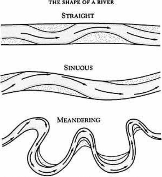
Meandering Rivers
The Büyük Menderes River, known also as the Meander River, is a river in southwestern Turkey that flows into the Aegean Sea between the near the ancient Greek city of Miletus. In antiquity, the river was celebrated for its numerous twists and turns, such that the term meander is now used to describe the regular sinuous curves of a channel of a river. The degree of meandering can be described by the sinuosity index (SI), or the “actual path length” divided by the “shortest path length” of a curve. In rivers, there are four classes of sinuosity:
SI < 1.05: almost straight
1.05 ≤ SI ≤ winding
1.25 ≤ SI ≤ 1.50 twisty
1.50 ≤ SI: meandering
Using this metric, we can classify a set of rivers by sinuosity. To find the sinuosity of a particular river, I needed to find the estimated river length as well as the coordinates of the river source and mouth. After finding these data points online, I used the Great Circle distance formula to determine the straight-line distance between mouth and source (as the bird flies). Dividing the listed distance of the river by the shortest path length yielded the sinuosity.
The list of rivers I selected was limited by my ability to find the relevant coordinates and distance data. I focused on a list of rivers that included the river Meander, the list of rivers in the United States over 500 miles in length, and a selection from the list of the longest rivers in the world.
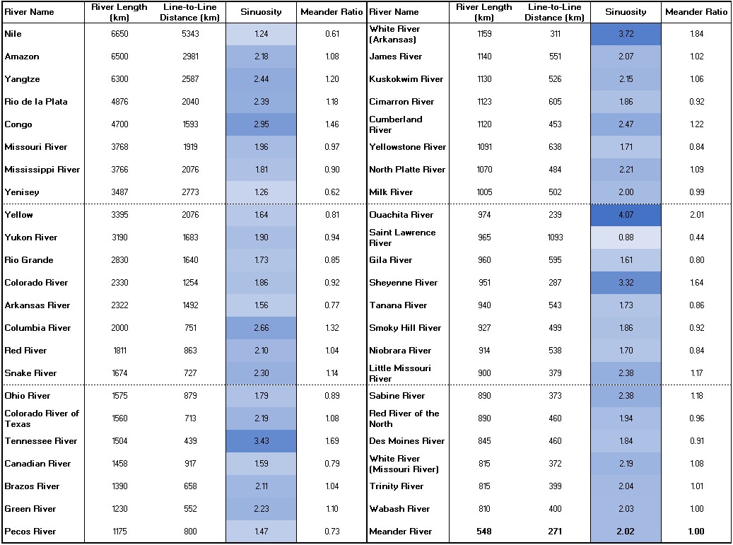
Of the 46 rivers, 42 of them had a sinuosity over 1.50 and can be classified as meandering. Moreover, I think we can safely state that the titleholder of the most-meandering river no longer belongs to the River Meander, as 23 of the rivers had a sinuosity greater than that of the Meander. Of these rivers, the 974-km-long Ouachita River, located in Arkansas and Louisiana, claims the title of “most meandering” river, at least of those I selected.
One river, the Saint Lawrence River, had a line-to-line distance calculated to be greater than that of the river length; of course, this is physically impossible, unless the river traverses underground below the earth’s surface, which does not seem to be the case.
Reflection
The results of this mini-analysis has many limitations. For one, the measured length of a river can vary considerably due to the resolution of measurement – à la the coastline paradox. In addition, many of the longer rivers have numerous tributaries that make it much more difficult to access river length. Moreover, rivers may have multiple sources and mouths that complicate measurement.
As an aside, the astute observer might have noticed that the featured image of this post is not actually that of a river at all, but rather of a design known by such names as a Greek Key or a meander, the latter term deriving from the Meander river.